Love or Hate
What’s the most unforgettable
experience? The truth is.
This picture is showing portions of Section 4 looking westward. Reeds parcel is on the left and Franko/St Pierre 571-030-037 is shown on the right.
How can a permit issued for Franko/St Pierre’s parcel be utilized on Reeds parcel 571-040-002? Both properties were sub divided in the late 1960’s. When permit #16245 was issued there was no connection between apn 571-030-037 and apn 571-040-002.
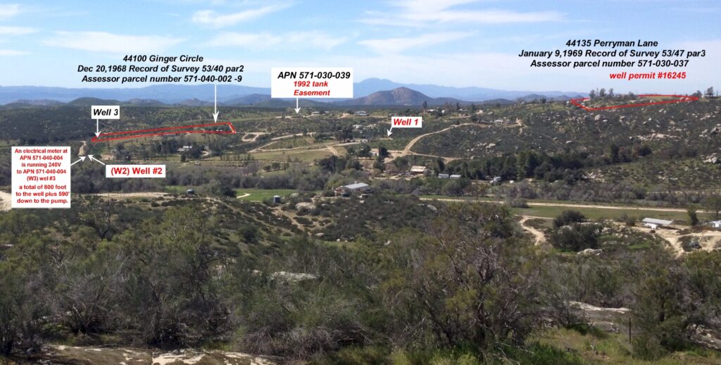
How can a permit issued in 1990 for Franko/St Pierre’s parcel be utilized on Reeds parcel 20 plus years later? Both properties were sub divided in the late 1960’s. When permit #16245 was issued there was no connection between apn 571-030-037 and apn 571-040-002.
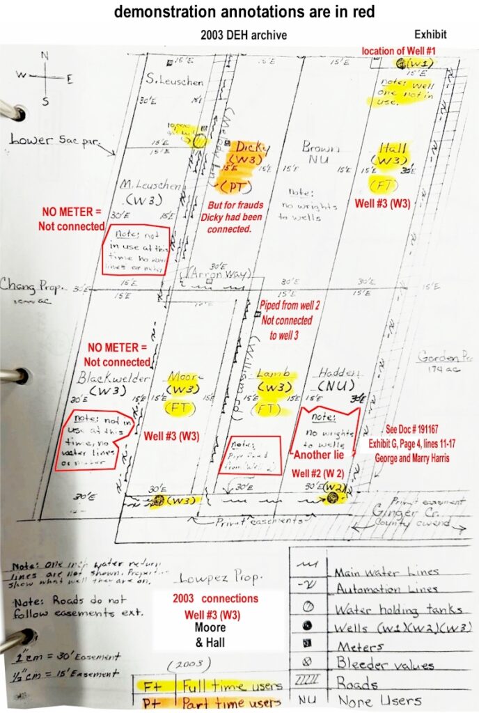
The following portion of a DEH map clearly identifies in 2003 only 3 connections to Reeds well (w3) were present.
§64215. Water Supply Requirements.
Prior to receiving permit approval, a state small water system which was not in existence on November 12, 1991 shall
demonstrate to the local health officer that sufficient water is available from the water system’s sources
and distribution storage facilities to supply a
minimum of three gallons per minute for at least 24 hours
for each service connection
served by the system.
§64215. Water Supply Requirements.
Prior to receiving permit approval, a state small water system which was not in existence
on November 12, 1991 shall demonstrate to the local health officer that sufficient water is
available from the water system’s sources and distribution storage facilities to supply a
minimum of three gallons per minute for at least 24 hours for each service connection
served by the system. The “system” did not function until June 11, 1992.
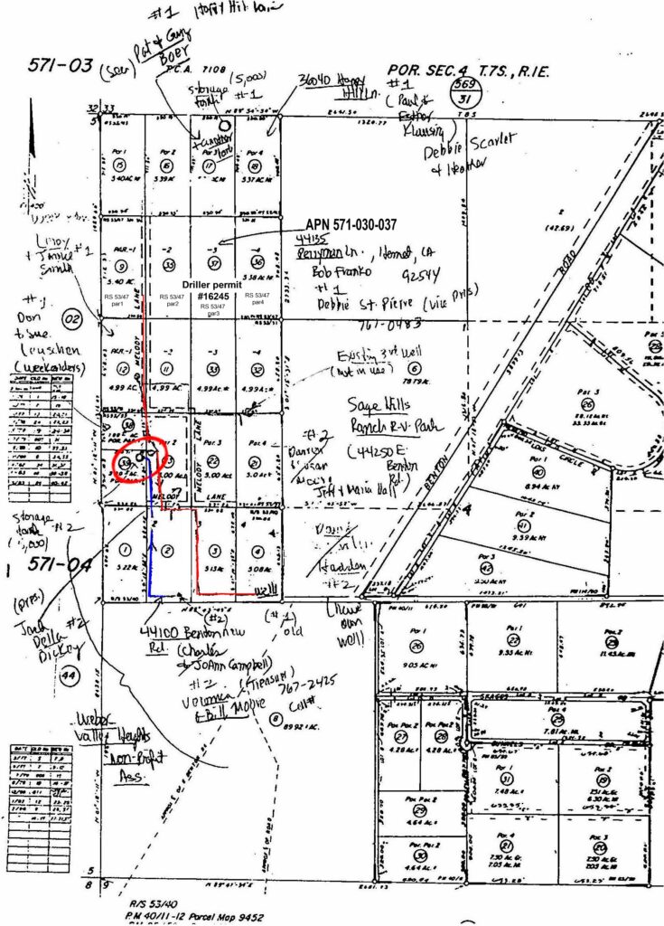
Without the colored annotations this following map was provided by Riverside County Department of Environmental Health. Take note of Well 1, well2 and well 3. The well identified as existing 3rd well was identified as well #1 in 2003 per a DEH achieved map file. This map shows well1, well2, and well3.
This letter further conveys two separate systems.
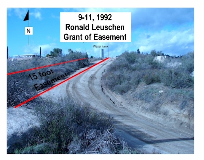
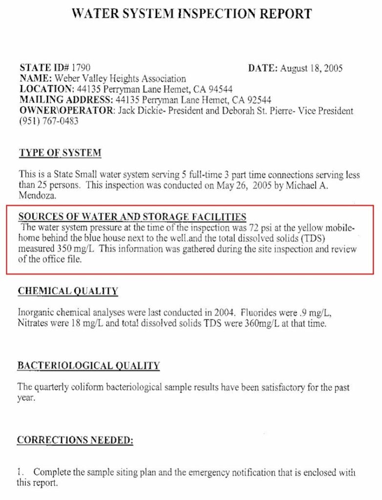
Riverside DEH has inspected a Water system over many, many years. As indicated by officially stored archives that remain on file. One inspection mentions the yellow house behind the blue house. This following property address is clearly showing 44240 as seen on the post. Commonly that parcel is known as 44240 East Benton. The underlying fee assessor parcel number 571-040-004. It has been said that this well shown below belongs to a Weber Valley Heights Water Association. The County recorders archives does not list a record of any such ownership. However, there is a 1985 Grant of easement to the well. The recitals thereto 100% fail to mention a benefactor named Weber Valley.
Therefore that third party singular entity is excluded as a benefactor.
Per CA Corp Code the association fails ownership rights of authority.
18100.See CA Corp Codes 18100, 1805 and 18110,
Sec 18100, The interest of a member in an unincorporated association is personal property.
105.Sec 18105, An unincorporated association may, in its name, acquire, hold, manage, encumber,
or transfer an interest in real or personal property.
Sec 18110, Property acquired by or for an unincorporated association is property
of the unincorporated association and not of the members individually.
18
1811


571-040-001
Area 1

571-040-002
Area 2.

571-040-003
Area 3.

571-040-004
Area 4.
Who we are
We are a combination of individual homeowners having granted rights that run appurtenant our land.

Our services
Research services done for you

County Recorder
Deeds past to present. Records of ownership truly identify who owned what.

DEH records
My request started in 2010, from there it was evidence somebody was lying.

A failed Association
In the early 1970’s people tried to form a 501 (c3) non profit business. They failed.
Testimonials
See what our friends say
about the facts.

Fantastic facts

Milly White
Finance Manager
Amazing how the facts provided a timeline true to specific elements related to an overall claim. Good job.
Dave Warren
Escrow executive
Most people would not have ever checked that energy source for a permit.
Mike Waldrop
Electrical Contractor.
Latest Blogs
Latest from the blog
Latest Blogs
Latest from the blog
I am here to help you learn the truth related to our property
The facts are based on records.